Berenty Reserve: A Research Site in Southern Madagascar |

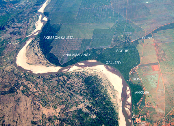
Aerial view of Berenty Reserve (with regions labelled)
Courtesy of Barry Ferguson and the Centre Ecologique de Libanona, www.libanona.com
Berenty Reserve: A Research Site In Southern Madagascar
Alison Jolly1, Naoki Koyama2 Hantanirina Rasamimanana3, Helen Crowley4 and George Williams5
1 Department of Biology and Environmental Science, University of Sussex, Brighton BN1 9QG, UK
2 Center for African Area Studies, Kyoto University, Kyoto 606-8501, Japan
3 Ecole Normale Supérieur, Université d'Antananarivo, BP 881, Antananarivo, Madagascar
4 Wildlife Conservation Society, BP 8500, Antananarivo, Madagascar
5 FontForge: http://fontforge.sourceforge.net
An excerpt of this article published in Ringtailed Lemur Biology, Jolly et al. eds, New York, Springer 2006 can be seen below. This and other articles from this book are available at the Springer site; see: Berenty Reserve: A Research Site in Southern Madagascar.
Berenty Reserve: A Research Site In Southern Madagascar (an excerpt) |
INTRODUCTION
The forest reserves of Berenty Estate were established by the de Heaulme family in consultation with local Tandroy clans, beginning in 1936 when the de Heaulmes founded a sisal plantation beside the Mandrare River (Jolly, 2004). Some 5000 hectares of spiny forest were felled, but 1000 hectares remain as original forest reserves. The reserves include a spiny forest parcel called Rapily, and two gallery forests, Bealoka (100 ha) and the main Berenty Reserve (200 ha) These two forests are islands of extremely rich habitat formed by ancient oxbow lakes or an entire river arm. They are dominated by Tamarindus indica, the tamarind tree. Berenty has the semi-arid climate of Madagascar's southern domain. Only along rivers with their high water table can tamarind forest survive; elsewhere there is the surreal succulent vegetation of Madagascar's spiny forest.
Originally the gallery forest was divided from the spiny forest by the steep banks of the old riverbed, easily traversed by lemurs, but with sharply different vegetation at top and bottom of the bank. The reserves might seem too small to matter for conservation, but they are the only gallery forests remaining below the headwaters, except for two much smaller sacred forests near Ifotaka and a tract of tamarinds across the Mandrare River from Berenty which has little undergrowth and sparse canopy. (Jolly, pers. obs,) Southern gallery forests are one of the most threatened forest types of Madagascar (See Sussman et al, 2006)
CLIMATE
Southern Madagascar alternates hot wet summers, with temperatures above 40 degrees C at mid-day, and cold dry winters, when temperatures fall below 10 degrees at night. Rainfall varies erratically from 300 cm to 900 cm per year, if calculated in lemur-years beginning Oct 1, which group all of a wet season together. Conventional years, starting Jan 1, group the end of one wet season with the beginning of the next, and so blur the degree of variation. In1991-92, when two thirds of the season's rain fell during a three-day storm in January. El Niño years usually mean drought for the south of Madagascar as for southern Africa, Ringtailed lemurs adapt their breeding and growth to the alternation of wet and dry seasons, but their life history strategies can only be understood in the light of recurrent catastrophic years (Gould et al., 1999; Richard et al., 2002; Wright, 1999).
BERENTY HABITAT ZONES
The main Berenty Reserve contains about 200 hectares of gallery and scrub forest connected on the west to a corridor of spiny forest, and on the east by a narrow interface to the 150-hectare Akesson/Kaleta forest. Its four habitat zones embrace a five-fold difference in ringtailed lemur population density.
....
The full article continues, including discussion of Berenty's Habitat Zones, Fauna, Ringtailed Lemur Studies at Berenty, and more.
| To access this full article, visit: http://www.springerlink.com/content/p4184pn22725228l/ |
|---|
_MASTimg_BreakfastMale_(DC).jpg)
_MASTimg_BerentyWebsiteMasthead.jpg)


