Breakfast Male Lemur
Research Scientists at Berenty
HOMEPAGE of the Berenty Website The Berenty Reserve Tourism Website The Ako Project


Berenty Mapping Systems
 
Many researchers now use GPS and GIS systems for mapping Reserve locations. However, with GPS they may experience any number of pitfalls, especially in a forested environment with dense canopy coverage or in temporarily losing a satellite signal. Landmarks such as individual trees may be difficult to precisely map, as also tracking animals, e.g., lemurs, moving across the terrain.

Below are a couple of previously used Berenty mapping systems:
 
 
Maps Using the Quadrant System - courtesy of Rija Rasamimanana (available as .pdf's--click on the image links below...)


Malaza Map (with quadrats)
 Malaza Map (with quadrats)
 
 
Ankoba Map (with quadrats)
 Ankoba Map (with quadrats)


Research MAP - Berenty mapping program by George Williams (archival -uses a legacy operating system)

 
zipped folder 1/ Mapping Program (application, zipped)
   
zipped folder 2/ Documentation (HTML files, zipped)
   
zipped folder 3/ Berenty Maps (zipped)


These GPS-based research maps, programmed and measured by George Williams of FontForge, divide the studied portion of the reserve into 25m x 25m quadrats. Williams' MAP program allows plotting of day ranges, home ranges, core areas of any given intensity of use, and a wide variety of other features including trails and green trail tags.

The green tag system was begun by O'Connor and Pigeon in 1983. These trail tags are numbered flagging tapes positioned every 25 meters along trails. They have been installed ad hoc as research areas grew, so the numbers are incomprehensible without a map. They have no relation to the quadrant system, but help to locate oneself or one's observations.


Maps of Berenty

   Image Placeholder here
Tourist trail map of Berenty Reserve © Artwork by Elizabeth Cossons


Berenty lies at about South 25° 0' and East 46° 18', in the semi-arid Southern Domain of Madagascar.

A panel by Elizabeth Cossens gives the location of all the reserves of Berenty Estate, including the gallery forests of Berenty and Bealoka Reserves, the spiny forest tortoise reserve of Rapily, the octopus tree reserve of Anjampolo. All the reserve parcels, including the many strips of spiny forest and small sacred forests around tombs hold ringtailed lemurs and white sifaka, lepilemurs and mouselemurs.

A second panel shows the main area of Berenty Reserve proper, with its walking paths. Berenty Reserve's habitat zones can be recognized on an air photo and there are research maps which allow plotting of data such as lemur ranges.

Climate of Berenty Reserve

    Madagascar Map (Mayaux)
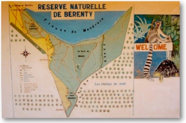
Berenty lies beside the Mandrare River in the semi-arid Southern Domain of Madagascar. It is in the rain shadow of the Anosy chain of mountains, in the crater caused by the eruption of the Anosy Volcano 88M years ago, which provoked the split of India from Madagascar.
   
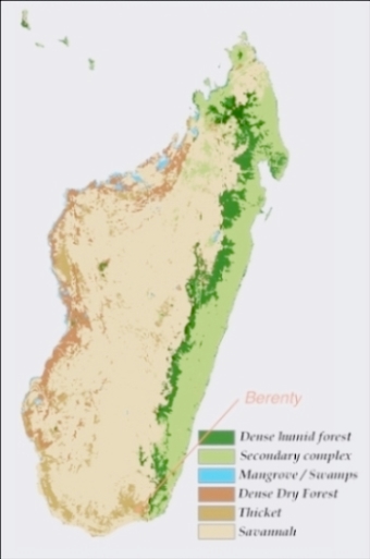
Madagascar Map © P. Mayaux
     

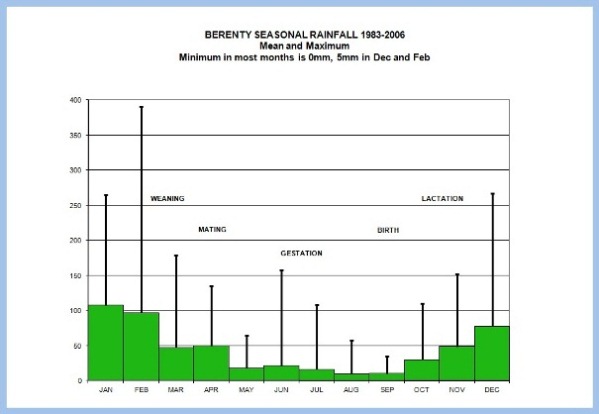
Berenty, like the rest of Western and Southern Madagascar, has cold dry winters and hot wet summers. This determines the breeding seasons of all plants and animals, and the rhythm of people's crops. All Madagascar lemurs wean their young at the richest time of year in February and March, which for ringtails means that the mothers must give birth at the end of the dry season, when their body condition is lowest. The means indicate mean monthly rainfall, and the error bars the maximum. Minimum is 0 in all months except January and February, when it is 5 mm.

  Seasonal Rainfall Chart  
 
Graph of seasonal rainfall. A. Jolly, data courtesy C. and A. Rakotomalala.


  Climate chart_fig 5  
 
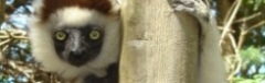
Graph of Berenty Rainfall, Years Starting Oct 1. A. Jolly, data courtesy C. and A. Rakotomalala.
 

Madagascar has extremely erratic climate from year to year. The south sufferes from both El Niño droughts and cyclone flooding. The figure shows "Lemur-years", beginning Oct 1 at the start of the wet season, when infant ringtails are born. This groups each wet season together, with its succeeding dry season. Drought years such as 1991-92 can bring famine to the region. Fruit failure in the forest occurs in some wet years, which can mean a lost cohort of infants for the lemurs.
 

Google Map of Berenty
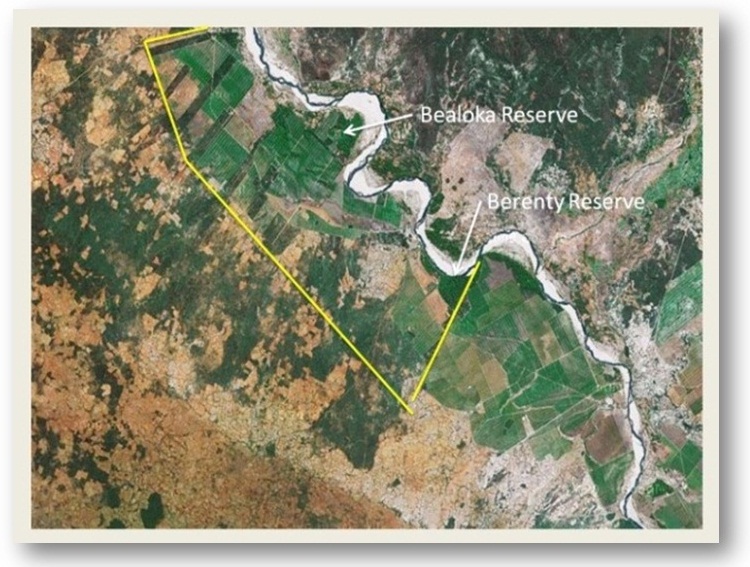
Berenty Estate, Google Earth